View Photo
| Photo Albums > Contemporary Photos > Soldier's Point |  |
 |
 |
 |
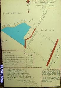
Copy of the Deed Map for Soldier's Point Coastguard Station, Point Road, Dundalk, dated Oct 1810. == A map and survey of a new plot of ground near the Salt House at the Soldier's Point of Dundalk intended for building. Two Acres One Rood & Twenty five Perches Irish Plantation Measure being 264 feet - 6 inches in front and 266 feet - 6 inches in Rere. Part of the Estate of the Right Hon. the Earl of Roden. Surveyd for his Lordship in October 1810 By Jn Birch & Son. Lease and other info.== 1810, Henry Maxwell to Hugh Howard & John Metge & Robert, Earl of Roden to The Commissioner's of Customs & John Straton Collector of Dundalk - 1813 & Charles John Allen Mac Lean - 1827 & Charles John Allen Mac Lean - 1847 / RENT PER YEAR = £17. ~~ For the building of houses & ofices for the Revenue Surveyor & Boatmen. ~~ Mr. Clarke - Paid £139 -9-8 for building wall in front of houses 1810. New Kitchen built 1815 (A new Customs House was built in Quay Street this same year. the new kitchen mentioned was built to the rear of the Commander's house as the small kitchen fireplace smoked badly , the new kitchen was built with a chimney which extended over six feet above the roof ridge to over come this problem)
Date: 28/03/2009
Added by: POYNT
Dimensions: 828 x 1200 pixels
Filesize: 308.68kB
Comments: 2
Number of views: 4996
Date: 28/03/2009
Added by: POYNT
Dimensions: 828 x 1200 pixels
Filesize: 308.68kB
Comments: 2
Number of views: 4996
Comments
#1 |
Tony
on 29/03/2009 00:00:24
#2 |
castlemaine
on 07/09/2009 12:16:31
Post Comment
Please Login to Post a Comment.


